January 29, 2026
I began this project sometime around December of 2020. The original idea was simple: tell and re-tell some of the stories of the people and places, along the way from Dallas to Lubbock. Nothing more complicated than that. I’ve worked on it for five years now, off and on, when time (and work and life) allow. I’ve met many great people, and I’ve been honored–sincerely I say this–with their stories.
Over time the stories have grown broader and deeper, to include not only the people, but also the land that sustains them, the highways that connect them, the gravestones that memorialize them, the hamburger joints that feed them, and the geology that moves them, from far below, imperceptibly, inexorably.
So the purpose of the project has evolved. Today, I’d describe it as a ‘deep map,’ in the tradition of William Least Heat-Moon (more on deep maps later). Less charitably, you might also describe it as a mongrel approach to a travel guide–too messy for scholars (not rigorous enough), too serious for tourists (too much context), too sincere for cynics (because I really do care).
The building of this deep map is an exploratory journey, itself a kind of ‘road trip.’ And any good road trip will have 1) traveling companion(s), and 2) some detours and dead-ends, some side roads and switchbacks. But rather than going back to revise everything, I’m going to leave the outtakes in, so to speak, and continue adding on to this “About” section, if and when necessary. And from here on, I’ll think of you not as “readers” but as fellow travelers, if that’s ok with Y’all. I’ll scooch over. Hop in.
Our first stop, is December, 2020.
December, 2020
The ideas, thoughts and unanswered questions that have eventually led to this project have been with me a long time, years in fact. Questions about the people and places on the way from Dallas to Lubbock, what it’s like to live here, what the stories are. These questions float up during this or any long road trip, that takes me out of the city and far into the countryside.
For those who’ve spent time in the Western or Southwestern US, a drive of five or six hours, even more, is not that big of a deal. Some of us look forward to these trips. The long and lonely stretches give your mind a chance to wander, to think things through. And the occasional landmark or small town or gas station, they appear on the horizon just in time to keep you from overthinking those very same things.
I stop to fill up. I go inside, get a cup of coffee. Weak, of course, but hot at least. I say “Hello” to the person at the register.
Where do they go when they finish their shift? I wonder to myself. To their homes, stupid. I know, but what’s it like, not just to pass through, but to live here? What do they do for fun? Any nicknames for the locals, or for those in the next town over? Any rivalries? Is there a town gossip? Of course there is, but do they…you know, stir up trouble?
In my younger years, I too lived in a small town, so I have some idea. But it wasn’t this small town; maybe it’s different here. Still, it’s best not to pry. Better stick to ‘normal’ questions.
“Next time I’m through here, where’s the best place to eat? Is that barbecue place any good? It’s alright? Okay. Thanks, see you later” I say, knowing I probably never will.
I head back to my car as someone else from somewhere else pulls in. I wonder where they’re going? Maybe they wonder that about me as well? Or not? Either way, you’ll never, ever, know. Because soon you’ll both be on your way, each at 75 miles an hour, in opposite directions, while the clerk remains, tending the register, sweeping the floor, turning out the lights, locking up…
I’m not sure if anyone else thinks like this, or if it’s strange to do so, but it just doesn’t sit well with me, that an hour from now, I might not remember much at all about this place, other than next time through, I should stop somewhere else for coffee.
So after years of wondering, of not knowing, I’ve finally decided to do something about it. I started this project to find some answers, and created this web site to share what I find.
January, 2021
Today I’m headed west on Highway 380, near Newcastle. Beautiful sunny Saturday afternoon, low 70s–warm for late January, cattle grazing on both sides of the highway.
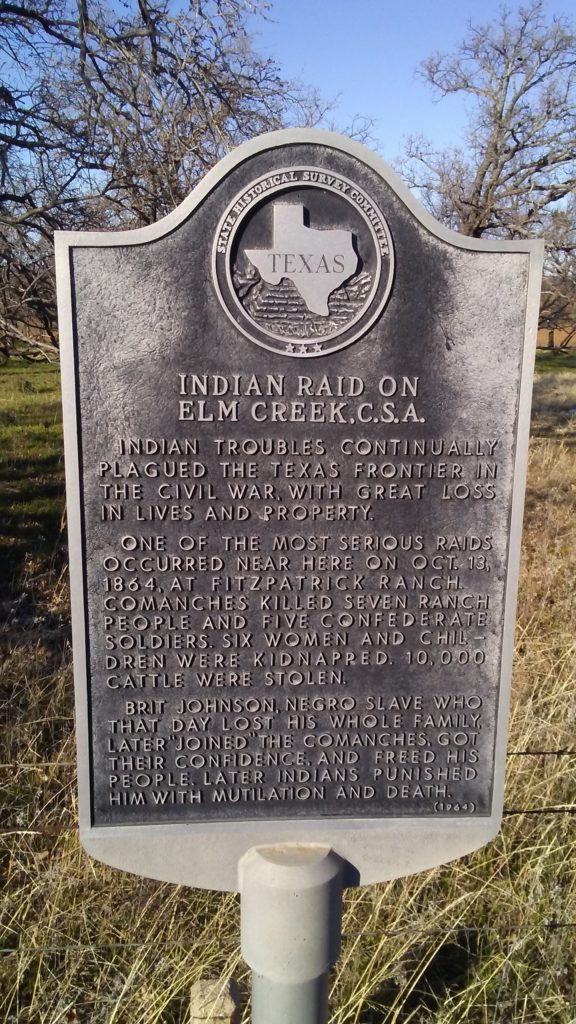
But if you’d been traveling through here in the autumn of 1864–on October 13th, to be exact–you’d have come across a very different scene, a tragically violent scene where 12 people were killed, six were kidnapped, and thousands of cattle stolen during the Indian Raid on Elm Creek.
Excavation at this site might turn up some buried shell casings or other artifacts. But I for one don’t need any physical ‘proof’ to already feel the realities of this place, past and present.
From here, the story can extend effortlessly in any number of directions. We could, for example, explore the life of Millie Durgin, one of those kidnapped during the raid, an infant at the time, who went on to live a long life with the Kiowa who abducted her, bearing nine children, and with 32 grandchildren and 12 great-grandchildren.
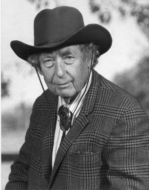
Or we can bring the story 100 years closer to the present, by exploring the Young County Survey Committee, the group responsible for erecting this marker in 1964, a century after the incident occurred. Committee members included: Mrs. J. W. Bullock, Committee Chair, of Newcastle, Texas, Mr. George Terrell and Dr. Kenneth Franklin Neighbours, a historian, who wrote several books on 1850s American Indian relations. Dr. Neighbours was a 1933 graduate of Olney High School, later earning his doctorate from the University of Texas. He taught at SMU in Dallas for several years, and was known for taking a balanced approach to his scholarship, that neither romanticized nor vilified either side.
Dr. Neighbours was also, say those who knew him, a flamboyant character and life-long bachelor. A voracious reader, he’d fill one room with books, then move on to the next, in the sprawling Victorian house in Wichita Falls where he lived in later years. The librarians in charge of archiving his collected works and papers told me they had their hands full, and with a lot of work still to do.
His life’s work and still-felt presence add yet another layer to the history of this place along Highway 380. As for it’s future, I’ll hold off on that, until I learn more.
What I can do now, is imagine a kind of radio that would allow us to tune in, not just to different broadcast frequencies, but to different times and epochs. Traveling through this place, we could tune in to the ‘news’ of today, or turn the dial back to hear the sounds of the construction crew as they installed this marker. Or farther back still, to hear the screams and gunfire that erupted on this very spot. And how far into the future would we have to tune, to hear languages other than our own, or sounds altogether unintelligible?
***
I’m just getting started with this project, but I’m optimistic. I’m struck by the variety and the richness of the stories I’ve heard already, and motivated by those still to be found along this 330 mile route. It’s a near-infinite number I’m sure, with current stories layered atop historical ones, and whatever envisioned future ones you might layer atop those–like a kind of multi-dimensional map, with past, present and future.
Update for 2026: A Deep Map of the Journey from Dallas to Lubbock
As ridiculous as this might sound, it’s only recently, after working on this project off and on for years, that I’m finally beginning to understand what it is, and can become: It’s a deep map. This project is a deep map of the journey from Dallas to Lubbock.
What I know now, but didn’t know when I began, is that the ‘multi-dimensional map’ I described above is very similar to what author William Least Heat-Moon calls a ‘deep map.’ He coined the term, and demonstrated it, masterfully, with his 1991 book “Prairyerth,” a deep map of Chase County, Kansas.
A deep map, according to Moon, might include an actual, physical map of a place. But it goes far beyond that, and might also include: folk lore, geology, natural history, and local stories, etc, all interwoven to create a richer, fuller and more immersive account of a place.
If the author’s successful, a deep map should resonate strongly and meaningfully with those familiar with the place. It should enable those who’ve never traveled there to come to know the place, even ‘experience’ it a little, through text, image, and voice.
Moon chose the location in Chase County, specifically the area around Cottonwood Falls and the Flint Hills region, because it’s right in the heart of one of the last remaining tallgrass prairie ecosystems in North America, the preservation of which he considers vital.
Says Moon: “I wanted to try to write a book about a place that Americans thought there’s nothing that happens there of interest,” but was actually a place rich with stories, past and present. Just like, as we’ll see, the people and places along the way from Dallas to Lubbock.
The discovery of Moon’s work was something of a ‘Eureka!’ moment for me. Standing on the shoulders of giants, indeed. Perhaps the ‘multi-dimensional map’ was possible after all. As for the time-traveling radio, we’ll have to wait a bit longer for that one.
Deep Map: A brief example
Imagine it’s mid-summer. You’re planning a trip with your wife, to get out of the heat and up into the cool of the mountain air for a few days. You’ve settled on a destination, one you know well, but haven’t been to in years, not since you used to take the family hiking there, back when the kids were still at home.
You pull up Google Maps on your phone, but some of the landmarks and back roads leading to your destination, some more like trails really, don’t appear. But not to worry. You go into the back bedroom, empty now except for an old chest–the “chest of junk drawers” as your wife calls it. You rummage around, then find it: the old paper map you used for years.
It smells musty as you unfold it onto the kitchen table. The markings along the folds are gone, but the detail and the back roads are all there. That first turn, off the main road, the one that’s easy to miss, especially in the summer when the foliage is thick; that hairpin turn, known forever as “cheeseburger corner,” because that’s what your son, made nauseous by the winding mountain roads, deposited there–outside the car fortunately, thanks to a quick pull-over by dad.
There’s the little ‘crossed pick and shovel’ icon, marking the abandoned mine shaft you didn’t explore, because of what happened at the other abandoned mine shaft up the road that you did explore, on an earlier trip, with family in tow and with disastrous consequences, narrowly avoided. Right at your planned destination there’s a small hole where you’d stuck a pin, with an exaggerated flourish, to show the kids precisely! where you all were headed.
A part of the route is hand drawn, because your daughter had traced the road with one of her colored pencils, and you got upset and told her she shouldn’t mark up the map like that. You tried to erase it, but the print came off too. Then she cried, then you cried too because you’d made her cry, and you hugged her tight, saying you were sorry and that it was just a stupid map after all. You had her draw it back in, for good this time, with a pen.
And now, decades later, another tear wells up, but with a smile, adding another layer of meaning to this old map. Except, it’s not just an old map, it’s a deep map, deep with memories and meaning from the past, and hope and anticipation for the future. ‘Hey let’s call the kids, ask if they want to join us.’
More to come…