Dear Fellow Travelers: I’m afraid I’ve let you down. Because despite all the stories and images and everything I’ve posted here over the last couple years, I’ve yet to include an account of the road trip for which this entire project is named: Dallas to Lubbock.
So I aim to at least begin to remedy this problem, with this story, focused more on the journey itself, from the high rises of Dallas, to the high plains of Lubbock. The idea is that for future additions, this story can be the ‘main route,’ from which a few detours and side trips can be made, if you’re interested.
Nothing Plenty to See Here, Folks
To begin, I’m thinking about the visitors who may happen along here to this site. The reach of the internet is global, and some visitors from places afar are no doubt unfamiliar with this part of the globe. For them, as long as I can do a good job of storytelling, then hopefully they’ll find this particular route, between these two foreign cities, to be an interesting one.
Another group of visitors/readers I’m thinking of, perhaps the largest group, are those much closer to home, mostly my fellow Texans. If you’re among this group, you’ll not only be familiar with these two cities of Dallas and Lubbock, but may actually be from, live or lived in, or traveled between them, perhaps many times.
For this more local audience, I suspect your reaction to finding not only a story, but an entire website, focused on the journey from Dallas to Lubbock, might be something like: “What? Dallas to Lubbock?” followed by “What in the Sam Hill…why there’s nothing out there! Why not just fly?” I imagine you locals are my toughest customers; the ones most difficult to convince that this particular road trip is one worth takin’.
Now in your defense, yes, it’s a fur piece–330 miles give or take. And at 5+ hours, it’s creeping close to that 7-hour ‘breakeven’ point, past which it’s usually quicker to fly than drive, according to travel writers (Texas, for better or (I believe) worse, is big enough to have its own version of ‘flyover country’–that’s another story for another time). And yes, once you clear the DFW Metroplex, there are no large cities. Abilene’s the largest at around 130k, and most of the towns along the way have just a few thousand.
But if you’re interested, and if you’re attuned to it, there’s plenty to see out here.
But let’s up the ante, shall we?
If you’ve ever worked with an editor, they’ll caution you: ‘don’t inflate the readers’ expectations, because if you can’t meet them, they’ll be disappointed.’ That might be good advice, but it’s also safe advice. And all too often, ‘safe’ slides right on over into ‘boring,’ don’t you think? Like hospital food, with no salt; or fireworks that spark but don’t fly up in the air–the only kind they sell out in California: safe but boring.
So to try and be not boring, and to satisfy even my toughest Texan visitors, I’ll commit to a high-risk/hi-reward stratergy, with this claim: The 5-hour road trip from Dallas to Lubbock is as eventful, with as much going on–past, present and future–as any other road trip of a similar duration that you can take, not only anywhere in the State, but in the entire country.
How’s that for inflating expectations?
Now that I’ve dug myself into a hole maybe even deeper than the one Bill Berry found himself in, I’ll get started and see if I can make good on these bold claims.
Dallas to Lubbock: Crossing the Great Divide
I want to begin with one significant geographical feature that forms the background for the entire trip. Then we’ll start back at the beginning in Dallas, and travel through four segments of the journey, leading us eventually into Lubbock.
Envision this, Fellow Traveler:
The date is Monday, April 1st, 1878. Your name is Major John Wesley Powell. Today, following nine years of expeditionary work, you will deliver your final report on the Colorado River and the western territories, first to the Commissioner of the General Land Office, and from there to the Secretary of the Interior and the 45th Congress, under President Rutherford Hayes.
Your discovery of a continental line of demarcation at the 100th meridian, and the consequences thereof, will remain fundamental to the settling and development the American west, for at least the next 150 years.
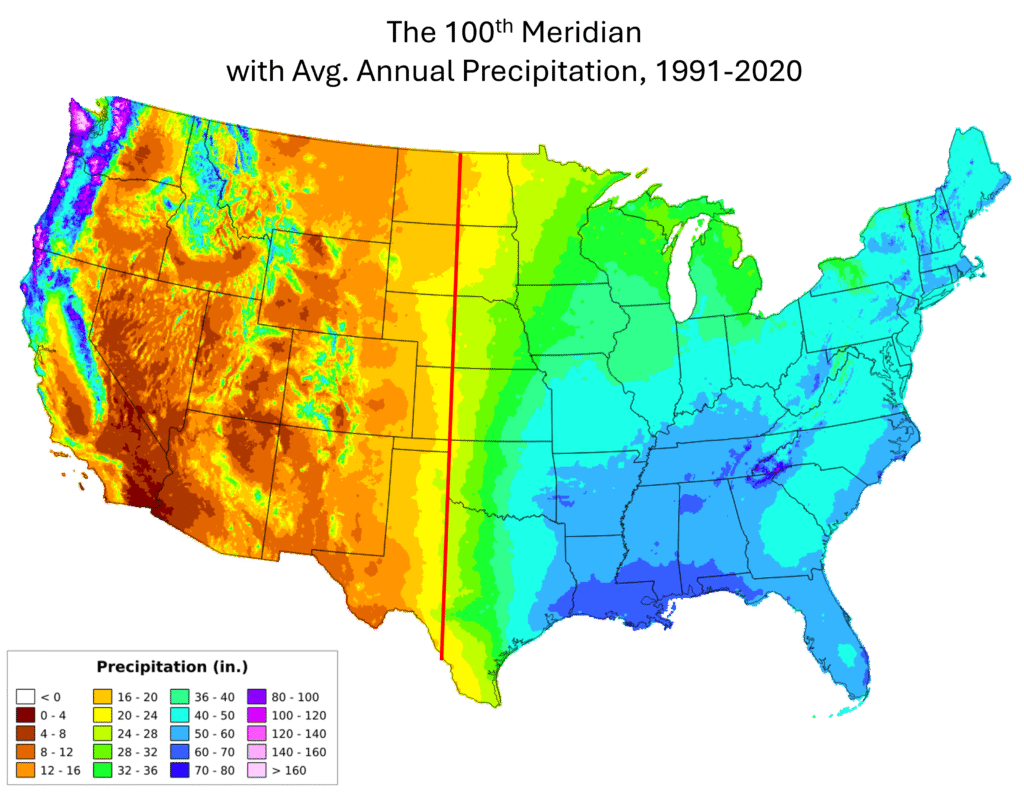
The 100th meridian, as many of you know, is the north-south longitudinal line, running pole to pole, that divides the continental US, and the state of Texas, roughly in half. I’ve seen this referred to as an ‘imaginary line,’ but the consequences are anything but imaginary–they’re very real, very visible, and continental in scale. The importance lies not in the meridian line itself, but in how life has and will continue to unfold very differently on the opposing sides of it.
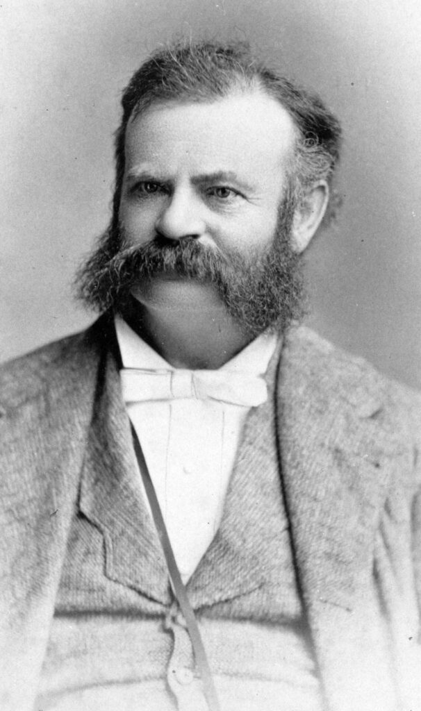
The first person to bring the importance of this line to our attention was explorer and geographer John Wesley Powell.
As Powell discovered, the 100th meridian is the continental dividing line between the verdant east, and the arid west. It also divides the lower elevations in the east, from the higher elevations in the west.
Looking at the map above, showing average annual precipitation, the line between east and west looks rather obvious. Indeed, breakthrough discoveries are often like this: they look obvious–in retrospect. In many cases, they’ve been right in front of us all along, but it takes visionary talent to actually see and articulate them.
Historically, these differences in rainfall and elevation affected the pace and pattern of westward migration and settlement, dividing the densely populated territories to the east, from the sparsely populated frontier territories to west. Today, the meridian line remains on the front lines of the still-ongoing battles of water scarcity and western development.
Fortunately for you, Fellow Travelers, all these changes and more are fully available for you to see and experience, on your way from Dallas to Lubbock, a route that will take directly across the 100th meridian.
High Rise to High Plains
Now, unlike your favorite action film, with car chases and sweating indecision over which bomb wire to cut, the action out here comes at you more slowly–even at rural Texas highway speeds. But unlike in the movies, the changes and the transitions along this way are very real indeed. Here are some specifics:
On the drive from Dallas to Lubbock you’ll go from from a “humid sub-tropical” climate,1 with 38 inches of rainfall annually, to a different climate altogether–a “semi-arid”2 one with less than half that amount of rain.3 You’ll climb from Dallas’ Trinity River bed, at 450 feet4 above sea level, to Lubbock, at more than 3,200 feet.5 You’ll travel from one of the least windy major cities in the US–Dallas, at #241 out of 255–to the windswept high plains of Lubbock at #15 on that same list. 6 Hold on to your hat!
And finally, what is certainly the starkest difference of all on either side of the meridian: population density. The population of Dallas is between and 3,000 to 4,000 people per square mile. The population density in Baylor County, where you will cross over the 100th meridian, about 13 miles west of Benjamin, is roughly 5 people per square mile.
So if you’re looking to escape the urban crush for a while, with this road trip you can leave DFW and within 90 minutes, be standing barefoot on the wide open grassland prairies that extend 1,300 miles to the north and well into Canada. (Just be careful of them fire ants out on that prairie grass, ‘specially if you’re barefoot.) You can follow along the paths of early settlers and dive into what was–and in many ways still is–the western frontier, cross over the 100th meridian, mebbe snap a silly selfie, and within a couple more hours be back to modernity, enjoying a chai latte with your besties in Lubbock
Go west, young man. OK , but which route?
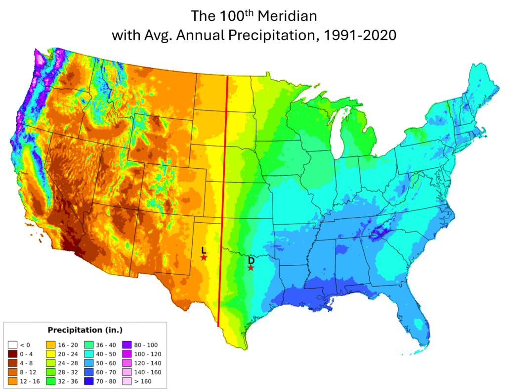
With the crossing of the 100th meridian as the backdrop to the entire trip from Dallas to Lubbock, the next question is which route to take. Texas roads and highways, all 80,000 miles of them,7 are laid out in a grid pattern, and there are at least four east-west route options to choose from.
The southern-most of these is along Interstate 20, through Abilene. Get a double espresso (and a T-Shirt) at Monks to power through. Just past Sweetwater, head northwest on Highway 84 to Snyder, Post, and on into Lubbock.
North of I-20 is the Highway 180 route, through Mineral Wells, Breckenridge, Albany, Anson, Pledger, and Roby. One grid line to the north will take you to Highway 380, which runs through Jacksboro, Bryson, Graham, Throckmorton, Haskell, Aspermont, Clairemont and Post.
And finally, what I call the ‘northern route,’ and my preferred route, is along Highway 114, taking you through Jacksboro, Olney, Seymour, Benjamin, McAdoo, Crosbyton, Idalou and on into Lubbock. It’s not the fastest route, but offers plenty of opportunities–indeed strong encouragement, depending on your degree of wanderlust–to slow down, to look around, and maybe even ‘set a spell.’
Creating Your Own Deep Map
I’ve been working on this project, off and on, for a few years now. I was well into it before I realized the route from Dallas to Lubbock would take me directly across the 100th Meridian. That wasn’t planning or foresight; it was serendipity.
hat route from Datakes you across the 100th meridian–without question one of the most significant changes, in the shortest time space that you can experience, compared to anywhere else on the continent–not an exaggeration
Because of the scale and impact of this natural line of demarcation, the stories on either side of this line and its significant influence on this territory–historical, present, and future–the stories, truth be told, kind of write themselves.
Granted the 100th is pretty special, but the route that crosses it is not necessarily any more grand than the routes that lead to and from wherever it is you call home.
If, that is, you’re willing to do a little study, dig a little deeper, or maybe even a lot deeper; talk in person with those who know the area well; and read the first-hand the historical accounts of those who’ve come and gone before us.
The stories are there. Your mission, should you decide to accept it, is to find them, then tell and re-tell them. Go on now, git!
- These are the Köppen classifications. More here. ↩︎
- And a source locale, of course, along with Phoenix, Bakersfield and other places, for one of the most pervasive lies ever told: “Yeah, but it’s a dry heat.” ↩︎
- NOAA National Centers for Environmental Information (NCEI). “U.S. Climate Normals, 1991-2020.” Released May 2021. ↩︎
- USGS ↩︎
- About Lubbock, published by Texas Tech University ↩︎
- Calculated from data provided by: NOAA National Centers for Environmental Information (NCEI), Comparative Climatic Data ↩︎
- Dawson, Carol, and Roger Allen Polson. Miles and Miles of Texas: 100 Years of the Texas Highway Department. Texas A&M University Press, 2016. ↩︎